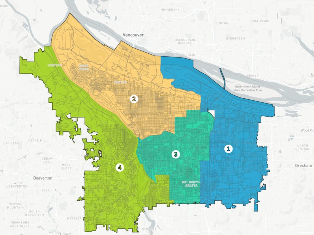
At last night’s meeting, the Independent District Commission unanimously selected a revised version of the Alder Map as Portland’s new map that defines four geographic voting districts for election of city councilors beginning in November 2024. Final deliberations were between the Alder and Maple maps, which were revised in response to public input. Ultimately the commission decided the revised Alder map was the best option for Portland, as it promoted strong collaboration and community engagement for the city’s future.
“Congratulations to the entire commission for prioritizing Portlanders in this historic process.” said City of Portland Chief Administrative Officer Mike Jordan. “In the coming weeks, the City of Portland Elections Office will work with our county partners to take the immediate next steps for the proper administration of district-based elections for City Council elections, and in the future, candidate and voter education.”
Details about the criteria and revisions to the Alder map
Approved by voters in November 2022, the new charter language required the commission to hold at least two public hearings in each proposed district before voting to adopt a final version of the district plan. The IDC used the criteria consistent with the Portland Charter, State and Federal law which requires that each district, as nearly as practicable:
- be contiguous and compact;
- use existing geographic or political boundaries;
- not divide communities of common interest;
- be connected by transportation links; and
- be of equal population.
Furthermore, no district was drawn to favor any political party, incumbent elected official or other persons or dilute the voting strength of any language or ethnic minority group.
Table 1, below, lists the recent revisions to the map based on public comments
| Area being changed | Edits to area being changed | Rationale |
| Sunderland neighborhood west of NE 33rd Ave (west of PDX) | Area west of NE 33rd Ave from Columbia River (north) to Columbia Slough (south) changes from East district (green) to N/NE district (orange) | Population within Sunderland neighborhood in a single district and City planning group request |
| Boundary between Roseway and Cully neighborhoods (Prescott to Mason along 63rd) | Two census blocks on the west side of NE 63rd change from SE district (teal) to N/NE district (orange) | Makes NE 63rd a uniform boundary so that neighbors on the west side of NE 63rd are all in a single district |
| Ardenwald-Johnson Creek neighborhod | Area south of SE Harney changes from West district (blue) to SE district (teal), and single census black south of SE Crystal Springs (between SE Cesar Chavez and half block to SE 42nd) changes from SE district (teal) to West district (blue) | Better alignment of neighborhoods along roadways, and makes SE Crystal Springs a uniform boundary so that neighbors on the south hside of SE Crystal Springs are all in a single district |
| Brooklyn neighborhood (south end) | Area bounded by SE Holgate Blvd (north), SE McLoughlin (west and south), and railyard (east) changes from West district (blue) to SE district (teal) | Entirety of neighborhood in single district |
| Montavilla/Jade District | Area bounded by SE Market & SE Mill (north), SE 82nd (west), SE Division (south), and I-205 (east) changes from East district (green) to SE district (teal) | Entirety of Montavilla neighborhood in single district, and better alignment to Jade District boundary based on input from community and organizations (APANO) |
The IDC worked with technical GIS consultants to collect data sets that helped to inform the criteria and as well as input from Portlanders on how they define their community of common interest. Then, the commission held discussions of the themes informed by a community survey, public comments, verbal testimony, and recent listening sessions. Those themes included geographic proximity, neighborhood boundaries, community facilities and amenities; rivers, natural areas, and landmarks; socio-economic factors; transportation access and infrastructure; eastside representation; unique community needs, cultural and historical significance, inclusivity, and service accessibility.
After working over the last two months to consider public comments and narrow the maps under consideration, the commission selected the Alder map.
An image file of the final district map with the district numbers on display is attached.
Next steps and resources
The IDC’s final vote to approve the district plan will be taken at 6 p.m. on Monday, August 21. The district plan will include the map approved by the Commission at the August 16 meeting, the legal descriptions of the districts and the assigned district numbers.
The City of Portland Elections Office is dedicated to helping voters and candidates understand the electoral landscape leading up to the 2024 election. Qualifying to the ballot and serving the city in this moment should be approachable and transparent for anyone interested in public service.
Find the newly released 2024 candidate guide, a step-by-step instruction manual with key dates and essential details about the election process and regulatory requirements on the Elections Office website. In conjunction with the transition team, the office will soon share a tool for all Portlanders to quickly review their district boundaries.
Web www.portland.gov/elections
Email elections@portlandoregon.gov
Phone (503) 865-6503
Office City Hall, 1221 SW 4th Avenue, Room 130, Portland, OR 97204
A final district map plan report will be available at a later date. Visit www.portland.gov/transition/districtcommission for more information.


